
Cultural Events | Zoos | Beaches | Restaurants | Sports Events | Theme Parks | Request Form | Home|

Craig Regional Park is characterized by rolling hills, ball diamonds, open space, and a formal rose garden. This unique landscape contributes to an overall sense of serenity and beauty. A variety of trees are interspersed throughout the park's 124 acres providing abundant shade.
A host of recreational opportunities exist at Craig Regional Park. Traditional turf play and picnic areas, bicycle and hiking trails are offered for visitor enjoyment. A 3-acre lake is open for fishing and the launching of model radio- controlled sailboats. Eight ramadas provide shade with tables and barbecues. The park's interpretive center provides visitors displays on the park's natural area where animals can be viewed in their natural habitat. The park offers a variety of recreational activities including three softball fields, two baseball fields, a jogging trail, equestrian trail, and a sports complex with basketball, volleyball, and racquetball/handball courts and two horseshoe pits. Three tot lots are available for children.
Craig Regional Park was named in honor of Mr. Ted Craig, a long time public servant in Orange County. Mr. Craig was elected to the Brea city Council in 1928 and served four years, the last two as Mayor. Craig also served in the California State Legislature representing Orange County during the 1930's.
Craig Regional Park is located in the cities of Fullerton and Brea adjacent to the Orange Freeway. To reach this facility. Take the Orange Freeway (#57) to the Imperial Highway offramp. Proceed west on Imperial for approximately 1/4 mile to State College Boulevard, then left for 300 yards.
Open: Nov. 1 - March 31, 7:00am to 6:00pm. Open: April 1 - Oct. 31, 7:00am to 9:00pm. Office Hours: Mon. - Fri., 8:00am to 4:00pm.
Ted Craig Regional Park 3300 State College Blvd. Fullerton, CA 92635 (714) 990-0271
Back to Top
Laguna Niguel Regional Park's 80 acres of turf surround a 44 acre lake, which is regularly stocked with catfish, bass and blue gill and trout during the winter months only. A large assortment of trees dot the park's 236 acreage providing beauty and shade.
Laguna Niguel Regional Park is dedicated to a wide variety of recreational uses. Two pedestrian bridges provide access to remote picnic shelters and hiking trails. Lake fishing for trout, (winter only) and bass, bluegill and catfish, (year round) is available for all park visitors. Bait and row boat rentals are available at the concession boathouse.
Picnic areas are equipped with shelters, sinks, picnic tables and barbecue stoves electrical outlets. An amphitheater is provided for youth and community organization activities. These facilities may be reserved through the park office. Turf areas, horseshoe pits, a par course along the parks two mile jogging trail, two sand volleyball courts and four lighted tennis courts are available for public enjoyment. Kite hill offers excellent conditions for remote control glider operations. Bicycle and equestrian trails meander throughout the park.
Laguna Niguel Regional Park was originally a part of the Mexican grant Rancho Niguel. This rancho was granted to Juan Avila in 1842 by Governor Alvarado. The ranch was named for a local Indian Village called "Niguil." Juan Avila, referred to as El Rico (The Rich), was considered one of California's finest rancheros because of his conservative way of life. In 1878, the rancho was rented from C. B. Rawson by L. F. Moulton. In 1881 Moulton bought out Rawson. Additional property was acquired and eventually the ranch consisted of 21,000 acres. One third of the ranch was later acquired by a man named Daguerre. In 1960 the Laguna Niguel Corporation purchased portions of the ranch. The Moulton family still retains 9,000 acres of the original ranch property.
Laguna Niguel Regional Park is nestled in the beautiful Laguna Hills. To reach the park take the Santa Ana Freeway (5) to the La Paz Road off ramp. Head west four miles to the park entrance.
Open: Nov. 1 - March 31, 6:00am to 6:00pm. Open: April 1 - Oct. 31, 6:00am to 9:00pm. Office Hours: Mon. - Fri., 7:30am to 3:30pm.
Laguna Niguel Regional Park 28241 La Paz Road Laguna Niguel, CA 92677 (949)831-2791
Back to Top
Irvine Regional Park is nestled among a grove of heritage Oak and Sycamore trees. The rolling foothills surrounding the park are filled with a variety of wildlife. Trees, shaded turf areas provide a serene setting for leisure activities. Santiago Creek bisects the park and a pond with stone-work waterfall and foot bridge is located in the center of the park. The variety of landscape greatly enhances the park's beauty.
Picnic tables and barbecues are located throughout the 477 acre park with convenient parking and restroom facilities nearby. A paved bicycle/walking trail meanders through the central park providing easy access to six playgrounds, four softball fields, two horse shoe pits, volleyball courts and lagoon.
A four mile equestrian trail skirts the perimeter of the central park providing scenic views of the park and it's natural scenery. Horse trailers can be parked on the north perimeter of the train station parking lot. A lookout trail is on the north slope of the natural area where a covered shelter, watering trough and water fountain are available.
Throughout its history, Irvine Park has housed a wide range of animals. William A. Kinsley succeeded Fay Irwin as superintendent in 1960. He built up a compound of birds and animals which became known as the park's zoo.
The park underwent a major renovation and redevelopment in 1982- 83. This included restoring the old buildings; redevelopment of the three group picnic areas; addition of three playgrounds and horseshoe pits; new turf and landscape; and relocating the roadways. A new zoo facility was also constructed which includes a children's barnyard area and native animal exhibits. The year 1983 also brought the listing of the park on the National Registry of Historic Places.
An Interpretive Center has been constructed in the historic exhibit hall. It has displays featuring the park areas natural, cultural, historical and recreational resources, and includes an audio/visual theater for interpretive presentations.
Irvine Park has a rich history, and contains some of the oldest Coast Live Oaks in Orange County. Concern for the preservation of the park's specimen oak trees necessitated much of the redevelopment and redesign of the park's facilities.
Irvine Regional Park is located in Santiago Canyon, six miles east of the City of Orange. To reach the park, take the Newport Freeway (#55) to the Chapman Avenue East offramp. Head east on Chapman for approximately five miles. Turn left on Jamboree for one fourth a mile to the park entrance.
Open: Nov. 1 - March 31, 7:00am to 6:00pm. Open: April 1 - Oct. 31, 7:00am to 9:00pm. Office Hours: Mon. - Fri., 8:00am to 3:45pm.
Irvine Regional Park 1 Irvine Park Road Orange, CA 92862 (714) 633-8074
Back to Top
Caspers Wilderness Park is an 8,000 acre protected wilderness preserve nestled among the river terraces and sandstone canyons of the western coastal Santa Ana Mountains. The park's many fertile valleys are overtly complemented by specimen groves of native Coastal Live Oak and magnificent stands of California Sycamore. These areas are further accentuated by seasonal wildflower displays and running streams. Wildlife is abundant and can be readily viewed from any of the parks numerous trails.
Caspers Wilderness Park affords the visitor numerous opportunities for primitive forms of recreation such as camping, picnicking, hiking, horseback riding, mountain biking, photography, nature study and astronomy. The park has campgrounds, restrooms and showers, picnic areas, an equestrian campground, hiking and equestrian trails and a future visitor center will offer the park user an insight into the park's history, wildlife and plant life.
Caspers Wilderness Park is located approximately 7-1/2 miles inland from the Mission City of San Juan Capistrano in Southern Orange County. To reach the park, take the Santa Ana (5) or San Diego (405) Freeway to the Ortega Highway (74) exit at San Juan Capistrano, Ortega Highway off ramp. Turn due east, inland, along Ortega Highway and proceed 7-1/2 miles to the park entrance.
Camping: Year round 7:00am - 10:00pm Day Use - 7:00 a.m. to sunset all year. Office Hours: 7:30am - 3:00pm, (Mon. - Fri.)
Ronald W. Caspers Wilderness Park 33401 Ortega Highway San Juan Capistrano, CA 92675 (949) 728-0235
Back to Top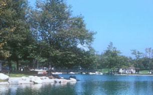
Mile Square Regional Park is an urban park located in the City of Fountain Valley and totals 640 acres of land. Within the park's boundaries are three regulation golf courses, two regulation soccer fields, baseball & softball diamonds, an archery range and a wilderness area. Also, there are two fishing lakes, concession operated bike and paddle boat operations, a wide expanse of picnic areas as well as numerous picnic shelters. Shelters serve a wide variety of visitors ranging from individuals to families and group organizations to annual company picnics.
65 acres of land located adjacent to Brookhurst is leased to the City of Fountain Valley for recreational purposes. This parcel has been developed by the city into a high-activity community park. Facilities provided by the city include a community center building, ball diamonds, basketball courts, outdoor play areas and a tennis court complex. Night lighting is provided on much of the outdoor facilities to extend playing hours.
Soccer, baseball, softball, cross country track meets, fishing and archery tournaments are among a few of the activities taking place at Mile Square. These activities provide a variety of recreational opportunities to meet most visitor interests. 62 acres, leased to the City of Fountain Valley, have been intensively developed by the City.
An executive 18-hole golf course, complete with a driving range, coffee shop with bar, and banquet room encompasses Mile Square's northwest border and a regulation 18-hole golf course, Complete with a driving range, club house, restaurant and proshop encompass Mile Square's southwest border.
Mile Square Regional Park is located in the City of Fountain Valley. To reach the park, take the San Diego Freeway (#405) to the Euclid offramp. Head north on Euclid to the park entrance. Or take the Garden Grove Freeway (22) to the Euclid offramp, and head south on Euclid to the park entrance.
Open: Nov. 1 - March 31, 7:00am to 6:30pm. Open: April 1 - Oct. 31, 7:00am to 9:00pm. Office Hours: Mon. - Fri., 8:00am to 4:30pm.
Mile Square Regional Park 16801 Euclid Ave Fountain Valley, CA 92708 (714) 962-5549
Back to Top
O'Neill Regional Park is situated in beautiful Trabuco and Live Oak Canyons. The park is heavily wooded with coast live oak and sycamore trees. The hillsides surrounding the park are filled with cactus, wild buckwheat, sagebrush and chaparral of scrub oak, buckthorn and mountain mahogany. Trabuco and Hicky Creeks also meander through the park, flowing in winter and early spring, dry in summer and fall.
The park serves both as an overnight camping facility and has day/picnic use. The picnic area provides for single and group uses and contains picnic tables, barbecues, a large turf area, horseshoe pits and playground equipment. 3.5 acres are available for RV groups on a reservations only basis. Camping is on a first-come-first- serve basis. Reservation can be made for organized groups of 17 or more.
The park facilities offer recreational opportunities including an equestrian campground, an arena and 18 miles of riding trails.
Programs covering the history and natural history of the O'Neill Park area are presented by rangers throughout the year.
Nature walks and special presentations are given upon request when personnel are available.
The park encompasses 3,100 acres. Its topography and appearance varies greatly with canyon bottom land, oak woodlands, grassy meadows, and shrub covered hillsides and slopes. At an elevation of 1,000 feet above sea level, the park enjoys warm dry summers and mild winters.
O'Neill Park is located 25 miles southwest of Santa Ana on County Highway 19 and 11 miles northwest of the San Diego Freeway via El Toro and Live Oak Canyon Roads.
Day Use Hours: Year round 7:00am to Sunset. Trails closed for 3 days following rain. Camping: Year round, 24 hours/day, 7 days/week.
O'Neill Regional Park 30892 Trabuco Canyon Trabuco Canyon, CA 92678 (949) 858-9365
Back to Top